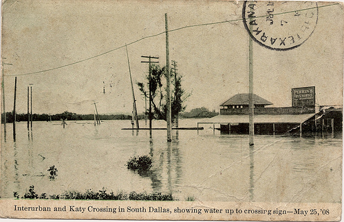
May of 1908 was rainy from Montana to Mexico. Floods had hit Kansas and Oklahoma that spring, and the Trinity River flooded in April.
But that was just a prelude. It rained 15 inches on May 25, 1908. And the next day, the river crested at 52.6 feet, which remains the record.
The flood killed five people and left 5,000 people homeless (out of a total population around 90,000). The total cost of the destruction reached about $2.5 million (which would be almost $65 million in today’s dollars).
In West Dallas, “…scores of families with scarcely more than their night clothing upon their bodies perched upon the roofs of their submerged houses, patiently waiting through the long hours of Monday morning for rescuing parties,” a newspaper reported at the time. From the rooftops, they could see looters at the edges of the floodwater stealing their “pigs, chickens, ducks and pet dogs.”
Most of the city was without power and water. Sewers were overflowing. Fires broke out. Trains couldn’t run. West Dallas, Downtown and the McKinney Avenue area were under water for days. But in West Dallas, the destruction and devastation to one of the city’s poorest neighborhoods was overwhelming.
A newspaper reporter surveying the damage two days later drove a buggy from Oak Cliff and wrote that the shoreline reached the bottom of the Beckley hill, probably near where Greenbriar is today.
…the roads leading to the river show wrecked and ruined store buildings and homes in which the water is swashing four feet deep … leaving acres upon acres of yellow mud deposit. Scattered rags of clothing are hanging upon broken wire fences. Clocks, furniture of all sorts, children’s toys and all manner of home effects are lying in the mud. Overturned outhouses, shattered stables and careening buildings are on every hand, some washed into an unfamiliar lodging place. Further out into the river are more roofs, generally twisted out of alignment or sloping crazily toward the retiring water. There are not a great many of them, but with the mud-covered wrecks closer in are what is left of the lower part of West Dallas.
The magnitude of the flood brought to light how poorly planned the city was.
Three years later, the city adopted a master plan known as the Kessler Plan, some of which was implemented over the following 10 years, to include levees, street improvements and rail facilities. The original east and west levees were built in 1928.
Major floods in 1989 and ’90 (also in April and May) destroyed 200 homes in South Dallas and Oak Cliff, causing about $30 million in damages, before the Rochester Levee was built.
Those are just the worst floods heavy rains in the Trinity have caused over the past 100 years or so. Dallas has a long history of floods, and we shouldn’t forget that.


