Photography by Rachel Stone, Art by Jessica Turner
Dallas now has 300 miles of trails, and about half of the planned system has been funded, completed, designed or is under construction.
Most of that work has been accomplished in the past 15 years.
“We can’t build trails fast enough for the demand we have,” says Jared White, a Park and Recreation Department manager.
When White first started as a bike planner over 20 years ago, it was a fight to get things done because homeowners thought trails near them would decrease property values or encourage riffraff.
“Now it’s like, ‘We want a trail by our house. Why is this taking so long?’” he says.
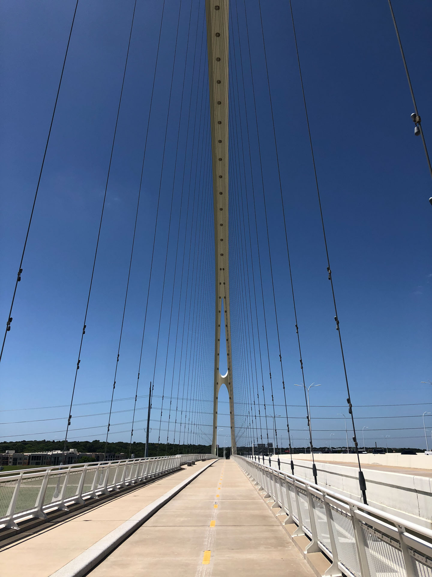
Trails cost about $1 million a mile, but the “cost per contact” over time is low because they require little maintenance and no staffing or building costs beyond that, says former City Councilmember Lee Kleinman, who shepherded the 9-mile Northaven Trail project over 15 years. That trail will be crowned with a signature bridge over Central Expressway, now under construction, that will connect five trail systems in Dallas, Richardson and Plano when it is completed in early 2023.
New sections of trails are opening all the time in Dallas. Neighbors have already started using an expansion of the Elmwood Parkway trail, spanning just over ½ mile, completing a connection between Tyler Station, Kiest Park and Five Mile Creek.
The 5.5-mile Honey Springs/Cedar Crest Trail opened near Beckley and Overton in October.
And it is now possible to take paved trails between the levees from Trinity Groves to Irving.
Like crossing paths with a dashing stranger in a coffee shop, a few tragic missed connections remain in our neighborhood.
With just about 90 miles left of the city’s overall trail plan left to fund, here’s where a few dots have yet to connect in our hike-and-bike life.

Bridge to where?
Little Midge is cute, but she was a difficult delivery.
“Value engineering” that saved some money on the front end in construction of the Margaret McDermott Bridge turned out to be a $7-million mistake that left two-way bike lanes on both sides unsafe to use for about four years after the Interstate 30 bridge was completed.
The city fixed it, and the pedestrian bridges opened last year, but they could be more than two years away from serving a meaningful transportation purpose.
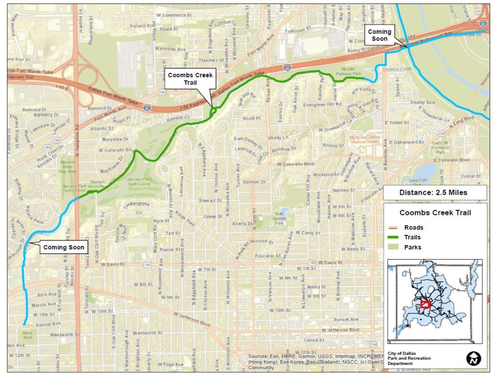
The good news: Kessler Park’s Coombs Creek Trail could connect across Beckley to the I-30 pedestrian bridge by this time next year, after months of negotiations with neighbors on which path to take across the westernmost levee, Mayor Pro-Tem Chad West says.
Two apartment complexes are under construction just south of the bridge, and zoning requires the developers to build wide sidewalks, which will create an easy pedestrian connection from the streetcar stop at Greenbriar.
Once those two things happen, the bridge will serve uniquely Dallas glamour as an expensive sculpture to ride or run back and forth on for a while.
Because, the bad news: Our swaggy Maggie ends at a six-lane road where there are not even sidewalks. A plan to completely rebuild Riverfront Boulevard means it could be at least two years before a connection is made on the other side of the river.
When that’s done, though, this should be like the Manhattan Bridge of Oak Cliff and West Dallas. Riverfront is planned as a complete street with bike lanes and sidewalks.
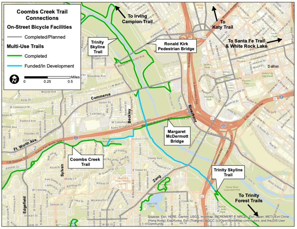
Bahama Drive/Plymouth Avenue
Meanwhile, on the western end of the Coombs Creek Trail, a connection between Kessler Plaza and Stevens Park is coming soon.
Bike lanes on both sides of Fort Worth Avenue currently stop at I-30 but are being expanded to Bahama Drive, and south from there to Plymouth. That project could be completed this year, says Jessica Scott, bicycle and mobility manager for the city’s transportation department.
Erosion control work is underway on the creek banks near Plymouth and Bahama, and the Coombs Creek trail will be expanded from Hampton Road, across West Davis and Jefferson Boulevard, to Moss Park.
Construction could start as early as this summer and is expected to take about a year.
“One of the biggest benefits of trails is connecting neighborhoods, and this is a great way to connect Kessler Plaza and El Tivoli all the way up to Stevens Park and beyond,” West says. “There are a lot of kids who will benefit from it, who live in the apartments on Bahama.”
Southern Dallas greenbelt
The Honey Springs/Cedar Crest Trail, which opened near South Oak Cliff High School last year, cost $7.2 million, of which $6.42 million came from Dallas County.
County Commissioner John Wiley Price championed the trail, working over several years with City Councilmember Carolyn King Arnold and city staff members, plus Oncor, who owns the utility easement where it’s built.
This nearly 6-mile trail will connect eventually into the planned Five Mile Creek Urban Greenbelt.
The greenbelt would span 23 miles, connecting a swath of Southern Dallas by trails.
But it’s not funded.
There’s an opportunity to fund it in the city’s next bond election, which is expected within a few years, but it will take a City Councilmember or very dedicated neighbor to push for it, White says.
“We as staff can identify priorities,” he says. “But if it doesn’t have a steward to push for it, things don’t get funded because there’s no one advocating for them.”
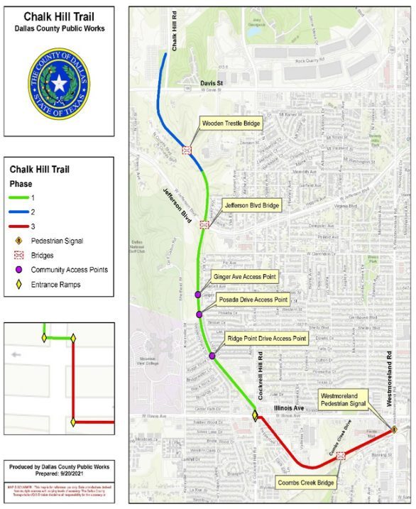
Chalk Hill Trail
Expect a community meeting on this trail planned for West Oak Cliff this year.
The 3.7 hike-and-bike trail will connect Westmoreland at Illinois to Chalk Hill Road in West Dallas, eventually. Like the Katy Trail, the Chalk Hill Trail will replace a defunct rail line, the Gulf, Colorado & Santa Fe.
A unique feature of the trail is the Mountain Creek Bridge, a remnant of the bygone interurban passenger rail line that used to run between Dallas and Fort Worth. The concrete bridge was designated a City of Dallas historic landmark six years ago.
The Chalk Hill Trail was first announced in 2016, when several community meetings were held, but it has been stalled since then.
Dallas County has earmarked about $6 million for the trail, and the city has agreed to pitch in a little over $3 million.
The first phase of construction, from Illinois at Cockrell Hill to just past Jefferson Boulevard, could begin next year, according to Dallas County. And it’s expected to cost about $8 million.
Phase two, from Jefferson to Chalk Hill Road, is expected to cost about $6 million. And phase three, from Cockrell Hill to Westmoreland, could cost about $10 million. Neither phase is currently funded.