A traffic calming study conducted by the Dallas Department of Transportation has found three possible options for handling the West Clarendon Drive corridor between South Westmoreland Road and South Tyler Street.
According to a presentation held by the city on Feb. 22, restriping the streets with bike lanes or parking could help slow speeds along the busy road and would advance the transportation goals of the West Oak Cliff Area Plan and Dallas Bike Plan. In the meeting, city staff also said a third option of leaving the road as it currently is could be pursued if neighbor feedback does not support bike lanes or additional parking.
In addition to the Feb. 22 meeting, the city published a survey that will be open until March 15.
Due to the roadway’s proximity to Arturo Salazar Elementary and Winnetka Elementary, the city also hopes to meet with 3rd or 4th grade students who use Clarendon to walk or bike to school about their experience using the street.
What are the current conditions along Clarendon?
Between South Westmoreland Road and South Tyler Street, Clarendon is currently striped as a two-lane road. But, according to city staff, the width of the road, which is 40-feet in most sections, leads to drivers using the road as a four lane to speed, and leads to uncertainty around street parking.
The speed limit posted along Clarendon is 30 mph, but the traffic study found the majority of drivers regularly speed five to eight mph above the posted speed.
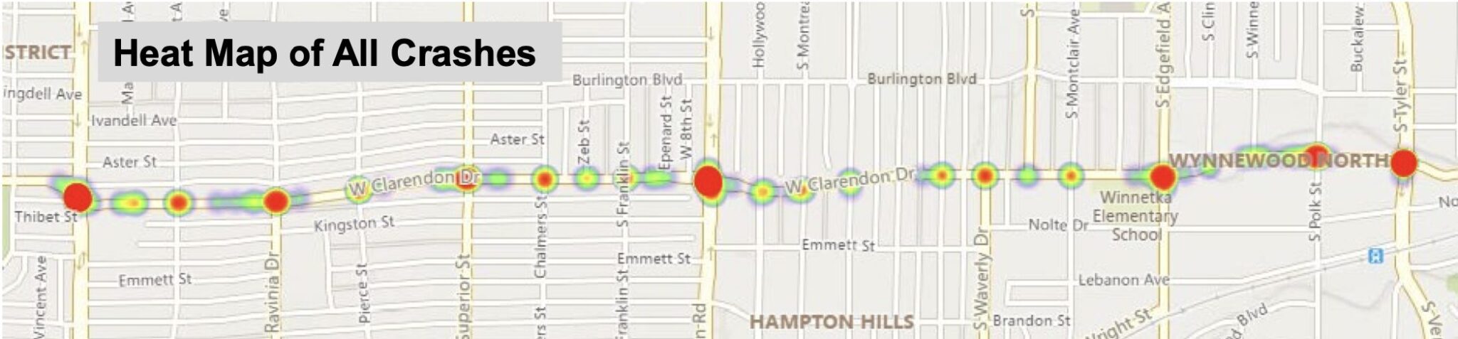
281 crashes occurred along Clarendon during the study period, the city said, 13 of which were fatal or resulted in severe injuries. 10 of those crashes occurred on Clarendon between Hampton and Westmoreland.
Driver inattention, failure to yield right-of-way to pedestrian or a turning vehicle, and driving under the influence were found to be the leading crash-causing factors.
What recommendations were made?
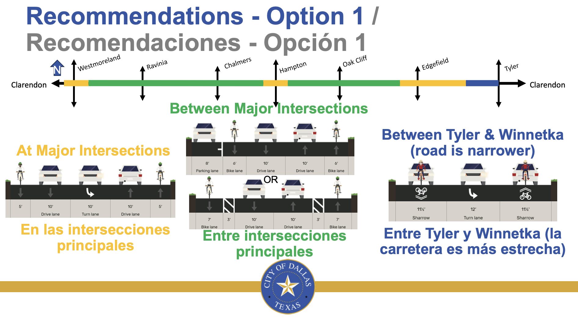
Option 1: The first option presented by the city would restripe the corridor with bike lanes, which can reduce crashes as much as 30% on two-lane, undivided roads.
This option would allow for two lanes of traffic, two bike lanes and a turn lane at major intersections, and either bike lanes divided from two lanes of traffic or bike lanes, traffic lanes and a street parking lane between major intersections between Westmoreland and Edgefield. From Edgefield to Tyler, where the street is a bit narrower, cyclists would merge with the main road to allow for a turn lane.
According to the city, this is the less expensive option and would connect cyclists to major destinations such as neighborhood schools and the Tyler/Polk DART station.
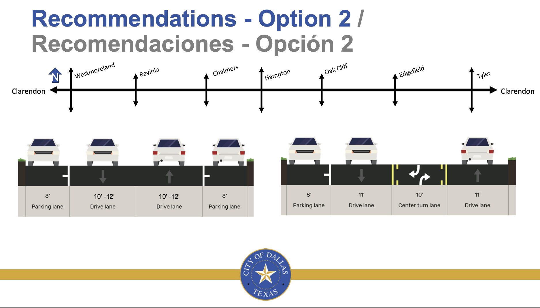
Option 2: The city also presented an option that would allow for parking along both sides of Clarendon next to the two-lane traffic, and would allow for turn lanes at major intersections.
Restriping could allow for turn lanes at Polk (westbound) and Edgefield (both directions) which the study determined is a need. In this option, a bicycle lane would be diverted along an alternative side street.
This option would be slightly more expensive than option 1, but would provide similar safety and traffic calming benefits.
Option 3: Leave the road as is.
Other recommendations and next steps?
The following recommendations were also made regardless of which option is chosen by neighbors:
- Install new all-way Stop signs at Clarendon Dr. and Barnett Ave.
- Add sidewalks to the north side of Clarendon Dr. between Zeb St. and Hampton Rd.
- Improve barrier-free curb ramps at all intersections to comply with American with Disabilities Act.
- Pedestrian push button enhancements needed at Clarendon Dr. and Westmoreland Rd.
Following community input, DDOT will identify funding and put together a plan for the roadway that will be voted on by the City Plan Commission Transportation Committee, the City Plan Commission and the City Council.