Photo by Rachel Stone
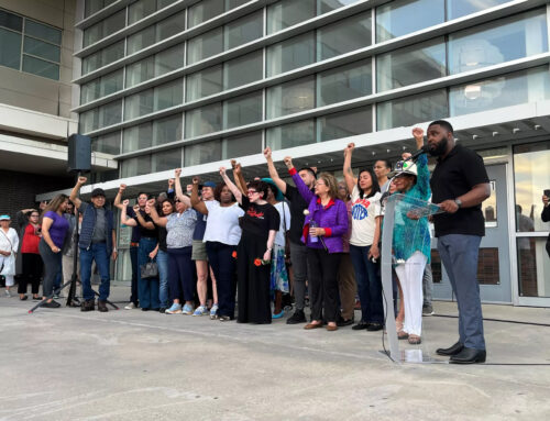
Residents and business owners in neighborhoods surrounding Greiner Middle School — between Clarendon Drive and 12th Street — gave public testimony in opposition to the West Oak Cliff Area Plan recently, and their grassroots resistance is heating up.
Prohibition of automotive-related businesses has been removed from the proposed land-use plan, but neighbors say they also want the plan’s recommendation for “missing-middle housing” eliminated.
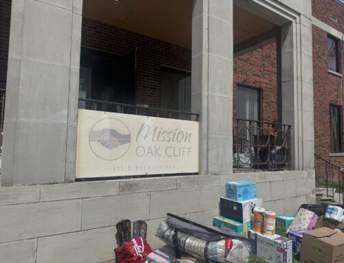
Neighbors say there hasn’t been enough outreach about the 184-page draft of the plan, and Spanish translation hasn’t been adequate.
At least one resident of the area testified at an Aug. 4 City Plan Commission hearing that she first heard about the plan from opposition organizers on social media.
Somos Tejas helped organize auto mechanics on Clarendon, who recently formed the Auto Association of Oak Cliff in response to the plan. Five or six mechanic-shop owners spoke at the meeting. Their petition succeeded in removing the “auto-related business” language, and they remain engaged in the plan.
The “lions share” of outreach has been done by outside groups, neighborhood resident Paulina Lopez told the plan commission.
“It should be on the city’s dime and the city’s time,” she said. “Others will do it if they have to, but they shouldn’t have to.”
Inadequate community engagement with the West Oak Cliff Area Plan shows that the City of Dallas needs to create an overall community engagement and outreach policy, Evelyn Mayo of Rayo Planning told the commission. Several commissioners agreed and noted that the idea is being considered.
Daniel Church, the Dallas Planning and Urban Design planner who has spearheaded the West Oak Cliff Area Plan, says community engagement has been robust.
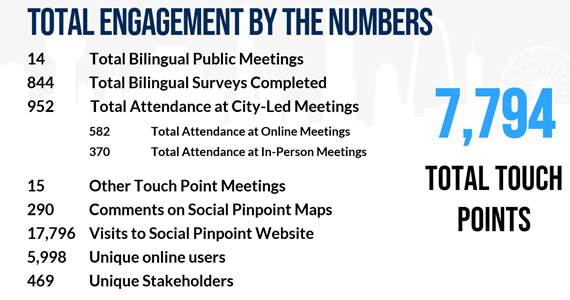
Staff is confident that the West Oak Cliff Area Plan conducted comprehensive, creative, and extensive community engagement, both in-person and virtually, while also leveraging creative new ideas for engagement including online interactive websites, in-person pop-up events, and educational events to meet the community where they are and maximize input for the plan. While there is no quantified standard for the amount of engagement required by a plan or process as a best practice by the City or by national planning associations as a whole, the West Oak Cliff Area Plan had over 7,500 touch points with the community, far exceeding one of Dallas’ most recent adopted area plans, The 360 Plan, for Downtown Dallas, which had 1,500 touch points (for an area 5 times larger than West Oak Cliff).
City of Dallas Planning and Urban Development
Mayor Pro-Tem Chad West had this response to critics of the draft plan:
The purpose of the West Oak Cliff Area Plan was to give Oak Cliff residents in these neighborhoods their first chance ever to put zoning protections in writing with the City of Dallas. Doing nothing has been the status quo for far too many parts of the city, and the result is always the same. Developers come in, buy up everything, tear it down, and put up apartments or something worse. Neighbors have uniformly said they want to keep their single family neighborhoods in tact and support small businesses. The plan does that. No Plan will provide a path for the status quo, an open door for developers.
What is ‘missing middle’ housing?
A July 5 draft of the West Oak Cliff Area Plan mentions “missing middle” housing 20 times and defines it, in part, as “the range of housing types between single-family homes and large multifamily apartments.”
Missing middle refers to duplexes, quadplexes and small apartment complexes that are common in older parts of town. An urban planner coined the term in 2010, according to this website that advocates for the product.
The draft plan makes the case that zoning throughout the 5.5-mile chunk of Oak Cliff the plan covers is singularly zoned in residential areas. There are single-family zones and multifamily zones, but there’s no flexibility.
From the draft:
This does not allow for these different housing options to exist in neighborhoods. Missing middle housing can enable neighborhoods to be for all family types and income ranges. Oftentimes, residents desire to remain in an area but have limited options if they cannot afford, or do not desire, a single-family home. This includes young people living alone for the first time or elderly persons who can no longer maintain a large house and yard.
Missing middle housing can also provide a transition between commercial and single-family areas, the plan states. Proponents say “missing middle” products are needed to create housing density to answer the escalating demand for places to live in Dallas.
But neighbors say “missing middle” is coded language to imply that new development is wanted, and they don’t want it.
“The missing middle housing recommendation should be removed from South Edgefield because they don’t want it, and their concerns are valid,” Christine Hopkins told the plan commission. “Existing homes more affordable than new construction will be.”
Hopkins, a lawyer who lives in Elmwood, noted that plenty of “missing middle” has been constructed recently in the Bishop Arts area, but none of it could be considered affordable.
New construction is epically expensive, while the existing homes in South Edgefield remain somewhat affordable, Hopkins says. She quoted a listing for a two-bedroom duplex for rent at $2,150. Homes in the neighborhood still sell as low as $200,000, and nothing is priced over $350,000.
Besides that, neighbors say the plan is too big and needs more work before proceeding to City Council.
“If the city of dallas is not going to listen to these working class minority neighborhoods now, then it seems to me a fait accompli that they will not be listened to when there is an accelerated authorized hearing process following this,” Hopkins to the plan commission.
She suggested that the plan instead should do more to protect the existing land uses, like putting restrictions on replatting, legally making one property out of many lots. Replatting is what made extreme redevelopment of the 500 block of West 8th, for example.
West says he hears neighbors’ call to remove “missing middle” language from the Tyler/Vernon station part of the plan.
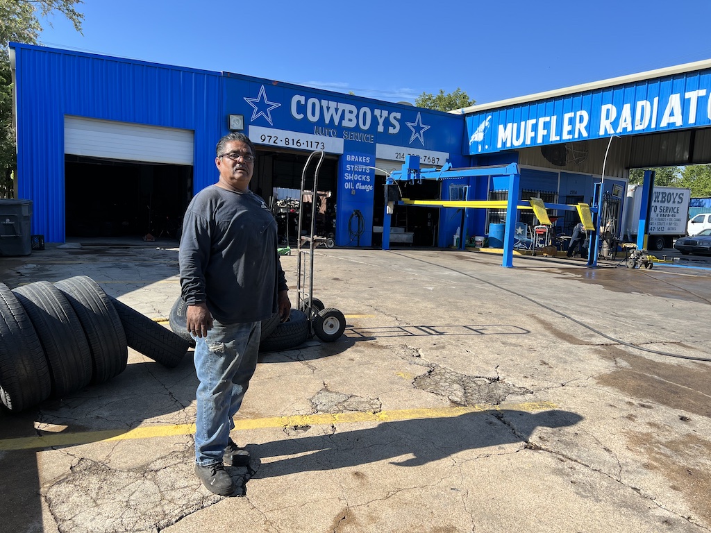
Clarendon Drive mechanic-shop owners got what they wanted in the West Oak Cliff Area Plan, and they remain engaged in the process, having formed the Auto Association of Oak Cliff because of the plan.
Neighborhood tour
City Plan Commission members will tour areas in the West Oak Cliff Area Plan Thursday morning, and that hasn’t been without its own controversy.
Neighbors say they were disappointed that the tour, as listed in the agenda, doesn’t include their recommended sites.
But the neighborhood-driven turn sheet wasn’t submitted in time to be included on the agenda, according to Church.
Hopkins says she and others spent six or seven hours on their turn sheet for the tour, so she sent it in an email to City Plan Commission members, urging them to drive the neighborhood-led route on their own.
Here are the turns the neighborhood recommends:
From Westmoreland, turn left at Falls Drive to pass Westmoreland Heights Plaza to see one of the blue “commercial corridor” areas on page 50 of the land-use map and a traditional Oak Cliff shopping plaza;
North Cliff: Cut up Pierce Street to see the entire core of the North Cliff Neighborhood Center, the site of an authorized hearing, rather than just the Pierce/Catherine intersection;
Kessler Plaza/Ravinia Heights: Continue north to Moss Park to see the core of one of the northern neighborhoods that feeds into the West Davis Corridor neighborhood mixed used focus area and see the Jefferson Blvd side of the West Davis Corridor toward Hampton;
Hampton thoroughfare: Head down Hampton to Clarendon to get a sense of Hampton as a six-lane commuter road, the transition on Hampton to a purely commercial corridor after the Tom Thumb plaza, and how the area designated “neighborhood mixed use” on Hampton feeds into the Hampton/Clarendon intersection where there are two authorized hearings on either side of the intersection — Jimtown back in the residential area, and Hampton/Clarendon in the auto shop/business area;
Jimtown downzoning: Continue on Hampton past Clarendon and turn onto Brandon Street in Jimtown to see the multifamily uses that are proposed to be down-zoned to single family uses in WOCAP and the upcoming Jimtown authorized hearing (we believe the City bus route turns onto a different street that has no current multifamily uses);
Clarendon land use transitions: Loop back up to Clarendon and head all the way down Clarendon to where it intersects with Nolte to will see how Clarendon transitions from a small business/auto repair area just past Hampton into single family residential uses, and then into the Winnetka Elementary School and small business intersection which includes Alebrijes Café and the nevería (and the murals on these buildings), and then how Clarendon transitions back to single family residential toward and past Polk (which is the entrance from Clarendon to the Tyler-Vernon DART) and past Tyler Street;
South Edgefield neighborhood: Loop from Clarendon to the end of Nolte and go down the entirety of Nolte toward South Edgefield, then up South Edgefield and down South Polk to the Elmwood Boulevard intersection to get a more complete overview of the housing stock in the South Edgefield neighborhood, including on the stretch of Nolte between Tyler and Polk that is directly north of Tyler-Vernon station. See where sidewalks are just now being constructed in this neighborhood with prior bond funds, and see many more areas where there are multiple rows of “orange lots” on the missing middle housing map including South Polk between Clarendon and Elmwood. Note the future home of Elmwood Neighborhood Farm at Polk and Nolte (an urban farming use not currently provided for in WOCAP) and the front of the Tyler Station building;
Wright/Lebanon Street: After seeing the parts of Elmwood that the city’s route also includes, go up Hampton from Elmwood and turn left on Wright Street. Follow Wright Street all the way down as it transitions to Lebanon and into Tyler-Vernon DART station to see how the housing stock north of Hampton DART differs from that South on Elmwood Blvd. Wright is the only road that directly connects the Hampton and Tyler-Vernon DART stations. See the housing stock on Lebanon, which is part of the South Edgefield neighborhood — this Wright/Lebanon route also contains many “orange lots” on the missing middle housing map, and you will see the newly installed sidewalks in that area;
Tyler two-way conversion to Jefferson: Get a last look at Tyler-Vernon DART station itself. Cutting through the DART bus path towards Tyler, turn left on Tyler to experience the new two-way conversion heading up to Jefferson, and as you head back to City Hall, see the cultural core of Jefferson. that was not included in the West Oak Cliff Area Plan, and if you follow it towards the I-35 Deck Park project, see the area of Ewing/Marsalis slated for apartment building construction as reported in this article.